In the digital landscape, maps serve as essential tools for navigation, analysis, and communication of spatial information. The transition from raster to vector maps holds immense significance, enabling enhanced clarity, scalability, and precision in geographical representations. This article delves into the process, benefits, and applications of converting raster maps to vector formats, elucidating their importance in various industries and endeavors.
Understanding Raster to Vector Maps
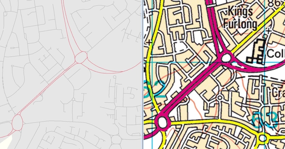
Raster maps are composed of pixels, often used in digital mapping and satellite imagery. However, when scaled or manipulated, raster maps might lose quality. Vector maps, on the other hand, utilize mathematical equations to define geographic elements, allowing for scalability without compromising clarity.
Converting Raster Maps to Vector
- Import Raster Map: Open the raster map in software like Adobe Illustrator, Inkscape, or other vector-based programs.
- Trace and Create Vectors: Utilize tracing tools within the software to manually trace geographic elements, such as roads, boundaries, and landmarks, converting them into scalable vector paths.
- Adjust and Refine: Fine-tune vector paths using editing tools to ensure accuracy and detail in the converted map. Adjust curves, nodes, and anchor points for precision.
- Save as Vector Format: Once satisfied with the vectorized map, save it in formats like SVG, AI, or PDF to preserve its scalability and editability.
Benefits of Raster to Vector Maps
- Scalability and Clarity: Vector maps maintain sharpness and clarity regardless of size alterations, crucial for various uses, including large-scale printing and digital displays.
- Editing Flexibility: Vector maps offer easy photo editing, allowing modifications to elements without losing quality, and facilitating updates and customization.
- Data Integration and Analysis: Vector maps enable the integration of data layers and analysis tools, enhancing their usability in geographical analysis and decision-making.
- Compatibility and Sharing: Vector formats are compatible with various software and platforms, allowing easy sharing and integration into different applications.
Applications of Vector Maps
- Cartography and Geographic Information Systems (GIS): Vector maps are extensively used in cartography and GIS applications for precise representations and analysis.
- Urban Planning and Development: Planning infrastructure and urban development benefit from scalable vector maps for detailed layouts and analyses.
- Navigation and GPS Systems: Vector maps facilitate accurate and clear navigation, providing seamless user experiences in GPS and mapping applications.
- Educational and Publishing Purposes: Educational materials, atlases, and publications utilize vector maps for clear and detailed geographic illustrations.
Conclusion
The conversion from raster to vector maps unlocks a realm of possibilities, enhancing clarity, scalability, and precision in geographic representations. By comprehending the conversion process and recognizing the benefits outlined in this article, individuals and industries can leverage vector maps for accurate navigation, detailed analysis, and effective communication of spatial information across diverse applications.
FAQs
Can all raster maps be accurately converted into vector format?
While most maps can be converted, complex or highly detailed maps might require additional manual adjustments for optimal vectorization.
Are there limitations to the size of raster maps that can be converted into vector format?
Larger maps may impact processing speed, but modern software can handle varying sizes, though processing times might increase.
Do vector maps retain geographical data from the original raster map?
Vectorization primarily converts graphical elements. Additional data integration might be required for specific geographical information.
Can vector maps be exported and used in GIS software for analysis?
Yes, vector maps exported from raster can be used in GIS software, allowing for detailed spatial analysis and data integration.
This page was last edited on 27 February 2024, at 11:14 am